Bunya Nut

by Jinibara artist Enid Morris
This painting etched into the Information Poles at the First Peoples Recognition Site in Mt Nebo is about the Dreaming Bunya Nuts that grow all over Wakka-Wakka, Jinibara and Gubbi-Gubbi Country.
The large oval shape is the Bunya nut itself. This massive cone can hold up to 60 to 80 Bunya seeds which is shown inside the Bunya nut cone itself. The Bunya nut cones grow on the trees and can be bigger than a football. The Bunya nut tree can grow cones every year but a large bumper crop of Bunya cones are grown every three years, and this is when in Traditional Times all the tribes gathered on the three tribal countries to do ceremony, marriage and enjoy the abundant food available.
The two sitting people represent the Male and Female cones. The Male cones are slim and much smaller than the female cones, and are usually found on the bottom part of the Bunya Nut tree. The Female cones sit high up in the tree tops and are round and heavy.
The long wriggly lines represent the pathway Aboriginal people used to travel to the Bunya Nut country. The Festival was one of the largest Traditional Festivals in Australia.
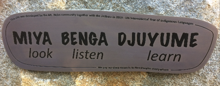
‘Miya, Benga, Djuyeme’ – ‘Look, Listen Learn’
‘Miya, Benga, Djuyeme’, ‘Look, listen, learn’ in the Jinibara language, is the central message portrayed in the First Peoples Recognition Site at Mt Nebo.
Nestled at the start of a walking track into Boombana National Park, near the central hub of the village, the site reminds us that wherever we are in Australia, in all directions, is Aboriginal land.
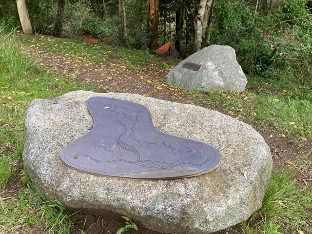
The central rock features an artwork map by Jason Murphy, which traces the Jinabara native title area. This is surrounded by four direction rocks showing neighbouring First Peoples language groups.
It reminds us that wherever we are in Australia, in all directions, is Aboriginal land.
The Mt Nebo community worked closely with the Jinibara to develop the site which was opened in 2019, the UN International Year of Indigenous Languages.
The map on the information rock gives us a deeper sense of place by depicting Jinibara country and other First Peoples regions in relation to the coastline. The map showing the four Jinibara clans, Garumngar, Nalbo, Dungidau and D’alla is based on an account given by Jinibara songman Gaiarbau (Grandfather Willie Mackenzie) to anthropologist L.P. Winterbotham in the 1950s. The Garumngar were likely the clan most closely connected to this area we now call Mt Nebo.

The Jinibara were formally recognised in 2012 by the National Native Title Tribunal as having long held native title to this area. Jinibara country covers the D’Aguilar, Blackall and Conondale ranges and some parts of the Sunshine Coast and Brisbane River. ‘Jinibara’ means people of the lawyer cane
The Recognition Site is a testament to deep respect and commitment from the Mt Nebo community to recognise and connect with First Peoples.
The Mt Nebo Residents’ Association invites our community and visitors to recognise and reflect on the Aboriginal history, spirit and culture of the area and deeply respect this place now called Mt Nebo – ‘Miya, Benga, Djuyeme’.

First Peoples Recognition Site
at entrance to Boombana National Park walking track near post office and cafe at Mt Nebo Village